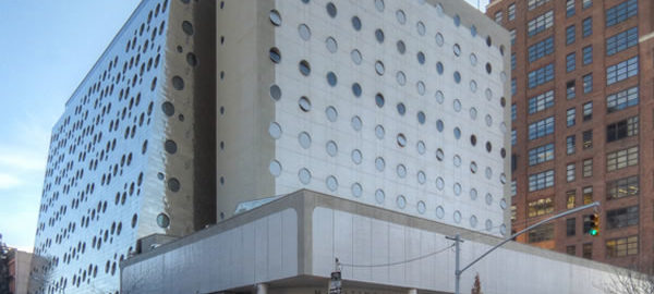
Once upon a time the National Maritime Union was so big it had three “headquarters” buildings in New York: The actual headquarters on Seventh Avenue between 12th and 13th Streets (Joseph Curran Building, 1964); an annex between 16th and 17th Streets just off Ninth Avenue (Joseph Curran Annex, 1966); and then a plaza – an annex to the annex if you will – that ran along Ninth Avenue (Joseph Curran Plaza, 1968). All three of the so-called Maritime Buildings were architectural standouts, designed by Bronx-born but New Orleans-based architect Albert C. Ledner.
Alas, New York’s maritime jobs dried up and the union sold all three buildings.
St. Vincent Catholic Medical Centers acquired the headquarters and renamed it the Edward & Theresa O’Toole Medical Services Building. St. Vincent’s later (2007) wanted to replace the O’Toole Building with a new 21-story hospital, but official NYC Landmark status (as part of the Greenwich Village Historic District) apparently saved it – temporarily. The Landmarks Commission later (2011) granted a “hardship” exemption allowing demolition. As of November, 2011, the plan is to keep the shell but demolish the interior and build a smaller facility: 140,000 square feet, down from 160,00 square feet. The conversion is to be completed by November, 2015.
Covenant House purchased the annex and plaza, after fighting off a challenge by then-Mayor Ed Koch, who wanted the buildings for a prison; later the plaza building was converted to the Maritime Hotel. The annex itself has been converted to the Dream Downtown Hotel. This is actually the second renovation of the annex. The building originally had 100 porthole windows in its sloping 12-story white tile facade; in later years the new owners built fake brick storefronts at ground level in an attempt to better blend in with the neighborhood (pictured on p. 179 of “Five Hundred Buildings of New York”). The Dream Downtown Hotel conversion has removed the fake storefronts and applied a metal skin. The windows are still round, but there are more of them on the 17th Street side and the overall effect is more like Swiss cheese rather than portholes. The 16th Street facade is now vertical, not sloping, and covered with a perforated dual-layer metal skin that frames 35 very large circular “windows” which are actually tiny balconies. The real (floor to ceiling) windows are behind.
The plaza building has changed the least. It was originally built as a dormitory for seamen; the nautical-themed hotel conversion was natural. And from the outside, “pizza box” is still an apt description.
Joseph Curran Building Vital Statistics
- Location: 36 Seventh Avenue between W 12th and W 13th Streets
- Year completed: 1964
- Architect: Albert C. Ledner
- Floors: 6
- Style: Modern
- New York City Landmark: 1969 (part of Greenwich Village Historic District)
Joseph Curran Annex Vital Statistics
- Location: 355 W 16th Street between Eighth and Ninth Avenues
- Year completed: 1966
- Architect: Albert C. Ledner
- Floors: 12
- Style: Modern
Joseph Curran Plaza Vital Statistics
- Location: 363 West 16th Street at 9th Avenue
- Year completed: 1968
- Architect: Albert C. Ledner
- Floors: 12
- Style: Modern
Maritime Buildings Suggested Reading
Google Map
![BAT_04_P8060029 [8/6/2011 11:22:11 AM] BAT_04_P8060029 [8/6/2011 11:22:11 AM]](https://www.newyorkitecture.com/wp-content/gallery/battery-battery-park/bat_04_p8060029.jpg)
![IMG_0588 [12/1/2011 12:02:50 PM] IMG_0588 [12/1/2011 12:02:50 PM]](https://www.newyorkitecture.com/wp-content/gallery/battery-battery-park/img_0588.jpg)
![BAT_05_P8050101 [8/5/2011 3:32:33 PM] BAT_05_P8050101 [8/5/2011 3:32:33 PM]](https://www.newyorkitecture.com/wp-content/gallery/battery-battery-park/bat_05_p8050101.jpg)
![BAT_05_0649 [7/27/2011 8:45:30 AM] BAT_05_0649 [7/27/2011 8:45:30 AM]](https://www.newyorkitecture.com/wp-content/gallery/battery-battery-park/bat_05_0649.jpg)
![BAT_05_0648 [7/27/2011 8:41:54 AM] BAT_05_0648 [7/27/2011 8:41:54 AM]](https://www.newyorkitecture.com/wp-content/gallery/battery-battery-park/bat_05_0648.jpg)
![BAT_05_0647 [7/27/2011 8:41:09 AM] BAT_05_0647 [7/27/2011 8:41:09 AM]](https://www.newyorkitecture.com/wp-content/gallery/battery-battery-park/bat_05_0647.jpg)
![BAT_05_0646 [7/27/2011 8:39:36 AM] BAT_05_0646 [7/27/2011 8:39:36 AM]](https://www.newyorkitecture.com/wp-content/gallery/battery-battery-park/bat_05_0646.jpg)
![BAT_05_0635 [12/1/2011 12:17:32 PM] BAT_05_0635 [12/1/2011 12:17:32 PM]](https://www.newyorkitecture.com/wp-content/gallery/battery-battery-park/bat_05_0635.jpg)
![BAT_05_0634 [12/1/2011 12:21:17 PM] BAT_05_0634 [12/1/2011 12:21:17 PM]](https://www.newyorkitecture.com/wp-content/gallery/battery-battery-park/bat_05_0634.jpg)
![BAT_00__3933 [10/22/2011 9:05:05 AM] BAT_00__3933 [10/22/2011 9:05:05 AM]](https://www.newyorkitecture.com/wp-content/gallery/battery-battery-park/bat_00__3933.jpg)
![BAT_04_P8060018 [8/6/2011 11:05:50 AM] BAT_04_P8060018 [8/6/2011 11:05:50 AM]](https://www.newyorkitecture.com/wp-content/gallery/battery-battery-park/bat_04_p8060018.jpg)
![BAT_03_P8040004 [8/4/2011 11:41:57 AM] BAT_03_P8040004 [8/4/2011 11:41:57 AM]](https://www.newyorkitecture.com/wp-content/gallery/battery-battery-park/bat_03_p8040004.jpg)
![BAT_02_09913 [11/30/2011 10:27:55 AM] BAT_02_09913 [11/30/2011 10:27:55 AM]](https://www.newyorkitecture.com/wp-content/gallery/battery-battery-park/bat_02_09913.jpg)
![BAT_02_09905 [11/30/2011 10:25:59 AM] BAT_02_09905 [11/30/2011 10:25:59 AM]](https://www.newyorkitecture.com/wp-content/gallery/battery-battery-park/bat_02_09905.jpg)
![BAT_01_P8060004 [8/6/2011 10:50:31 AM] BAT_01_P8060004 [8/6/2011 10:50:31 AM]](https://www.newyorkitecture.com/wp-content/gallery/battery-battery-park/bat_01_p8060004.jpg)
![BAT_01_P8060001 [8/6/2011 10:49:31 AM] BAT_01_P8060001 [8/6/2011 10:49:31 AM]](https://www.newyorkitecture.com/wp-content/gallery/battery-battery-park/bat_01_p8060001.jpg)
![BAT_01_3512 [10/20/2011 3:59:24 PM] BAT_01_3512 [10/20/2011 3:59:24 PM]](https://www.newyorkitecture.com/wp-content/gallery/battery-battery-park/bat_01_3512.jpg)
![WAT_15_10163 [11/30/2011 12:04:43 PM] WAT_15_10163 [11/30/2011 12:04:43 PM]](https://www.newyorkitecture.com/wp-content/gallery/water-street-corridor/wat_15_10163.jpg)
![WAT_10_09968 [11/30/2011 10:53:58 AM] WAT_10_09968 [11/30/2011 10:53:58 AM]](https://www.newyorkitecture.com/wp-content/gallery/water-street-corridor/wat_10_09968.jpg)
![WAT_10_10003 [11/30/2011 11:02:35 AM] WAT_10_10003 [11/30/2011 11:02:35 AM]](https://www.newyorkitecture.com/wp-content/gallery/water-street-corridor/wat_10_10003.jpg)
![WAT_10_10121 [11/30/2011 11:46:52 AM] WAT_10_10121 [11/30/2011 11:46:52 AM]](https://www.newyorkitecture.com/wp-content/gallery/water-street-corridor/wat_10_10121.jpg)
![WAT_10a_10032 [11/30/2011 11:14:33 AM] WAT_10a_10032 [11/30/2011 11:14:33 AM]](https://www.newyorkitecture.com/wp-content/gallery/water-street-corridor/wat_10a_10032.jpg)
![WAT_11_2433 [12/4/2011 2:54:55 PM] WAT_11_2433 [12/4/2011 2:54:55 PM]](https://www.newyorkitecture.com/wp-content/gallery/water-street-corridor/wat_11_2433.jpg)
![WAT_11_10566 [11/30/2011 2:46:42 PM] WAT_11_10566 [11/30/2011 2:46:42 PM]](https://www.newyorkitecture.com/wp-content/gallery/water-street-corridor/wat_11_10566.jpg)
![WAT_11_10569 [11/30/2011 2:47:46 PM] WAT_11_10569 [11/30/2011 2:47:46 PM]](https://www.newyorkitecture.com/wp-content/gallery/water-street-corridor/wat_11_10569.jpg)
![WAT_12_10130 [11/30/2011 11:53:33 AM] WAT_12_10130 [11/30/2011 11:53:33 AM]](https://www.newyorkitecture.com/wp-content/gallery/water-street-corridor/wat_12_10130.jpg)
![WAT_12a_P8130100 [8/13/2011 1:46:38 PM] WAT_12a_P8130100 [8/13/2011 1:46:38 PM]](https://www.newyorkitecture.com/wp-content/gallery/water-street-corridor/wat_12a_p8130100.jpg)
![WAT_13_2439 [12/4/2011 2:56:52 PM] WAT_13_2439 [12/4/2011 2:56:52 PM]](https://www.newyorkitecture.com/wp-content/gallery/water-street-corridor/wat_13_2439.jpg)
![WAT_13_2463 [12/4/2011 3:00:16 PM] WAT_13_2463 [12/4/2011 3:00:16 PM]](https://www.newyorkitecture.com/wp-content/gallery/water-street-corridor/wat_13_2463.jpg)
![WAT_13_10160 [11/30/2011 12:03:07 PM] WAT_13_10160 [11/30/2011 12:03:07 PM]](https://www.newyorkitecture.com/wp-content/gallery/water-street-corridor/wat_13_10160.jpg)
![WAT_13a_10157 [11/30/2011 12:02:24 PM] WAT_13a_10157 [11/30/2011 12:02:24 PM]](https://www.newyorkitecture.com/wp-content/gallery/water-street-corridor/wat_13a_10157.jpg)
![WAT_10_09965 [11/30/2011 10:53:39 AM] WAT_10_09965 [11/30/2011 10:53:39 AM]](https://www.newyorkitecture.com/wp-content/gallery/water-street-corridor/wat_10_09965.jpg)
![WAT_15_10169 [11/30/2011 12:06:47 PM] WAT_15_10169 [11/30/2011 12:06:47 PM]](https://www.newyorkitecture.com/wp-content/gallery/water-street-corridor/wat_15_10169.jpg)
![WAT_15_10178 [11/30/2011 12:08:17 PM] WAT_15_10178 [11/30/2011 12:08:17 PM]](https://www.newyorkitecture.com/wp-content/gallery/water-street-corridor/wat_15_10178.jpg)
![WAT_15_10199 [11/30/2011 12:16:19 PM] WAT_15_10199 [11/30/2011 12:16:19 PM]](https://www.newyorkitecture.com/wp-content/gallery/water-street-corridor/wat_15_10199.jpg)
![WAT_16_10187 [11/30/2011 12:10:27 PM] WAT_16_10187 [11/30/2011 12:10:27 PM]](https://www.newyorkitecture.com/wp-content/gallery/water-street-corridor/wat_16_10187.jpg)
![WAT_16_10234 [11/30/2011 12:27:11 PM] WAT_16_10234 [11/30/2011 12:27:11 PM]](https://www.newyorkitecture.com/wp-content/gallery/water-street-corridor/wat_16_10234.jpg)
![WAT_16_10238 [11/30/2011 12:29:08 PM] WAT_16_10238 [11/30/2011 12:29:08 PM]](https://www.newyorkitecture.com/wp-content/gallery/water-street-corridor/wat_16_10238.jpg)
![WAT_17_10517 [11/30/2011 2:28:01 PM] WAT_17_10517 [11/30/2011 2:28:01 PM]](https://www.newyorkitecture.com/wp-content/gallery/water-street-corridor/wat_17_10517.jpg)
![WAT_17_10554 [11/30/2011 2:39:28 PM] WAT_17_10554 [11/30/2011 2:39:28 PM]](https://www.newyorkitecture.com/wp-content/gallery/water-street-corridor/wat_17_10554.jpg)
![WAT_17_10557 [11/30/2011 2:39:55 PM] WAT_17_10557 [11/30/2011 2:39:55 PM]](https://www.newyorkitecture.com/wp-content/gallery/water-street-corridor/wat_17_10557.jpg)
![WAT_18_10288 [11/30/2011 12:44:01 PM] WAT_18_10288 [11/30/2011 12:44:01 PM]](https://www.newyorkitecture.com/wp-content/gallery/water-street-corridor/wat_18_10288.jpg)
![WAT_19_10297 [11/30/2011 12:46:03 PM] WAT_19_10297 [11/30/2011 12:46:03 PM]](https://www.newyorkitecture.com/wp-content/gallery/water-street-corridor/wat_19_10297.jpg)
![WAT_19_10503 [11/30/2011 2:26:37 PM] WAT_19_10503 [11/30/2011 2:26:37 PM]](https://www.newyorkitecture.com/wp-content/gallery/water-street-corridor/wat_19_10503.jpg)
![WAT_00_P9160093 [9/16/2011 11:05:17 AM] WAT_00_P9160093 [9/16/2011 11:05:17 AM]](https://www.newyorkitecture.com/wp-content/gallery/water-street-corridor/wat00_p9160093.jpg)
![WAT_05_10051 [11/30/2011 11:20:47 AM] WAT_05_10051 [11/30/2011 11:20:47 AM]](https://www.newyorkitecture.com/wp-content/gallery/water-street-corridor/wat_05_10051.jpg)
![WAT_00_09913 [11/30/2011 10:27:55 AM] WAT_00_09913 [11/30/2011 10:27:55 AM]](https://www.newyorkitecture.com/wp-content/gallery/water-street-corridor/wat_00_09913.jpg)
![WAT_01_09921 [11/30/2011 10:32:29 AM] WAT_01_09921 [11/30/2011 10:32:29 AM]](https://www.newyorkitecture.com/wp-content/gallery/water-street-corridor/wat_01_09921.jpg)
![WAT_01_09925 [11/30/2011 10:37:30 AM] WAT_01_09925 [11/30/2011 10:37:30 AM]](https://www.newyorkitecture.com/wp-content/gallery/water-street-corridor/wat_01_09925.jpg)
![WAT_01_09928 [11/30/2011 10:38:53 AM] WAT_01_09928 [11/30/2011 10:38:53 AM]](https://www.newyorkitecture.com/wp-content/gallery/water-street-corridor/wat_01_09928.jpg)
![WAT_02_09898 [11/30/2011 10:21:21 AM] WAT_02_09898 [11/30/2011 10:21:21 AM]](https://www.newyorkitecture.com/wp-content/gallery/water-street-corridor/wat_02_09898.jpg)
![WAT_02_09901 [11/30/2011 10:22:10 AM] WAT_02_09901 [11/30/2011 10:22:10 AM]](https://www.newyorkitecture.com/wp-content/gallery/water-street-corridor/wat_02_09901.jpg)
![WAT_03_09857 [11/30/2011 10:01:41 AM] WAT_03_09857 [11/30/2011 10:01:41 AM]](https://www.newyorkitecture.com/wp-content/gallery/water-street-corridor/wat_03_09857.jpg)
![WAT_03_09866 [11/30/2011 10:09:58 AM] WAT_03_09866 [11/30/2011 10:09:58 AM]](https://www.newyorkitecture.com/wp-content/gallery/water-street-corridor/wat_03_09866.jpg)
![WAT_03_09916 [11/30/2011 10:30:02 AM] WAT_03_09916 [11/30/2011 10:30:02 AM]](https://www.newyorkitecture.com/wp-content/gallery/water-street-corridor/wat_03_09916.jpg)
![WAT_04_09851 [11/30/2011 9:59:56 AM] WAT_04_09851 [11/30/2011 9:59:56 AM]](https://www.newyorkitecture.com/wp-content/gallery/water-street-corridor/wat_04_09851.jpg)
![WAT_04_09855 [11/30/2011 10:00:36 AM] WAT_04_09855 [11/30/2011 10:00:36 AM]](https://www.newyorkitecture.com/wp-content/gallery/water-street-corridor/wat_04_09855.jpg)
![WAT_05_09893 [11/30/2011 10:16:42 AM] WAT_05_09893 [11/30/2011 10:16:42 AM]](https://www.newyorkitecture.com/wp-content/gallery/water-street-corridor/wat_05_09893.jpg)
![WAT_05_10036 [11/30/2011 11:16:06 AM] WAT_05_10036 [11/30/2011 11:16:06 AM]](https://www.newyorkitecture.com/wp-content/gallery/water-street-corridor/wat_05_10036.jpg)
![WAT_00_09888 [11/30/2011 10:15:25 AM] WAT_00_09888 [11/30/2011 10:15:25 AM]](https://www.newyorkitecture.com/wp-content/gallery/water-street-corridor/wat_00_09888.jpg)
![WAT_05a_10046 [11/30/2011 11:19:49 AM] WAT_05a_10046 [11/30/2011 11:19:49 AM]](https://www.newyorkitecture.com/wp-content/gallery/water-street-corridor/wat_05a_10046.jpg)
![WAT_07_10061 [11/30/2011 11:27:26 AM] WAT_07_10061 [11/30/2011 11:27:26 AM]](https://www.newyorkitecture.com/wp-content/gallery/water-street-corridor/wat_07_10061.jpg)
![WAT_07_10067 [11/30/2011 11:29:39 AM] WAT_07_10067 [11/30/2011 11:29:39 AM]](https://www.newyorkitecture.com/wp-content/gallery/water-street-corridor/wat_07_10067.jpg)
![WAT_07_10084 [11/30/2011 11:34:09 AM] WAT_07_10084 [11/30/2011 11:34:09 AM]](https://www.newyorkitecture.com/wp-content/gallery/water-street-corridor/wat_07_10084.jpg)
![WAT_08_09980 [11/30/2011 10:58:21 AM] WAT_08_09980 [11/30/2011 10:58:21 AM]](https://www.newyorkitecture.com/wp-content/gallery/water-street-corridor/wat_08_09980.jpg)
![WAT_08_10022 [11/30/2011 11:11:27 AM] WAT_08_10022 [11/30/2011 11:11:27 AM]](https://www.newyorkitecture.com/wp-content/gallery/water-street-corridor/wat_08_10022.jpg)
![WAT_08_10028 [11/30/2011 11:12:29 AM] WAT_08_10028 [11/30/2011 11:12:29 AM]](https://www.newyorkitecture.com/wp-content/gallery/water-street-corridor/wat_08_10028.jpg)
![WAT_08_10108 [11/30/2011 11:45:17 AM] WAT_08_10108 [11/30/2011 11:45:17 AM]](https://www.newyorkitecture.com/wp-content/gallery/water-street-corridor/wat_08_10108.jpg)
![WAT_09_09992 [11/30/2011 11:00:30 AM] WAT_09_09992 [11/30/2011 11:00:30 AM]](https://www.newyorkitecture.com/wp-content/gallery/water-street-corridor/wat_09_09992.jpg)
![WAT_09_10006 [11/30/2011 11:04:00 AM] WAT_09_10006 [11/30/2011 11:04:00 AM]](https://www.newyorkitecture.com/wp-content/gallery/water-street-corridor/wat_09_10006.jpg)
![WAT_10_09952 [11/30/2011 10:49:27 AM] WAT_10_09952 [11/30/2011 10:49:27 AM]](https://www.newyorkitecture.com/wp-content/gallery/water-street-corridor/wat_10_09952.jpg)
![WAT_10_09962 [11/30/2011 10:52:16 AM] WAT_10_09962 [11/30/2011 10:52:16 AM]](https://www.newyorkitecture.com/wp-content/gallery/water-street-corridor/wat_10_09962.jpg)
![SSS_11_10364 [11/30/2011 1:08:58 PM] SSS_11_10364 [11/30/2011 1:08:58 PM]](https://www.newyorkitecture.com/wp-content/gallery/south-street-seaport/sss_11_10364.jpg)
![SSS_11_10241 [11/30/2011 12:32:06 PM] SSS_11_10241 [11/30/2011 12:32:06 PM]](https://www.newyorkitecture.com/wp-content/gallery/south-street-seaport/sss_11_10241.jpg)
![SSS_11_10250 [11/30/2011 12:34:15 PM] SSS_11_10250 [11/30/2011 12:34:15 PM]](https://www.newyorkitecture.com/wp-content/gallery/south-street-seaport/sss_11_10250.jpg)
![SSS_11_10261 [11/30/2011 12:36:01 PM] SSS_11_10261 [11/30/2011 12:36:01 PM]](https://www.newyorkitecture.com/wp-content/gallery/south-street-seaport/sss_11_10261.jpg)
![SSS_11_10277 [11/30/2011 12:41:35 PM] SSS_11_10277 [11/30/2011 12:41:35 PM]](https://www.newyorkitecture.com/wp-content/gallery/south-street-seaport/sss_11_10277.jpg)
![SSS_11_10280 [11/30/2011 12:42:16 PM] SSS_11_10280 [11/30/2011 12:42:16 PM]](https://www.newyorkitecture.com/wp-content/gallery/south-street-seaport/sss_11_10280.jpg)
![SSS_11_10283 [11/30/2011 12:42:49 PM] SSS_11_10283 [11/30/2011 12:42:49 PM]](https://www.newyorkitecture.com/wp-content/gallery/south-street-seaport/sss_11_10283.jpg)
![SSS_11_10342 [11/30/2011 12:59:47 PM] SSS_11_10342 [11/30/2011 12:59:47 PM]](https://www.newyorkitecture.com/wp-content/gallery/south-street-seaport/sss_11_10342.jpg)
![SSS_11_10343 [11/30/2011 1:00:50 PM] SSS_11_10343 [11/30/2011 1:00:50 PM]](https://www.newyorkitecture.com/wp-content/gallery/south-street-seaport/sss_11_10343.jpg)
![SSS_11_10358 [11/30/2011 1:03:50 PM] SSS_11_10358 [11/30/2011 1:03:50 PM]](https://www.newyorkitecture.com/wp-content/gallery/south-street-seaport/sss_11_10358.jpg)
![SSS_10_10361 [11/30/2011 1:05:17 PM] SSS_10_10361 [11/30/2011 1:05:17 PM]](https://www.newyorkitecture.com/wp-content/gallery/south-street-seaport/sss_10_10361.jpg)
![SSS_11_10370 [11/30/2011 1:11:32 PM] SSS_11_10370 [11/30/2011 1:11:32 PM]](https://www.newyorkitecture.com/wp-content/gallery/south-street-seaport/sss_11_10370.jpg)
![SSS_11_10373 [11/30/2011 1:12:17 PM] SSS_11_10373 [11/30/2011 1:12:17 PM]](https://www.newyorkitecture.com/wp-content/gallery/south-street-seaport/sss_11_10373.jpg)
![SSS_11_10381 [11/30/2011 1:13:34 PM] SSS_11_10381 [11/30/2011 1:13:34 PM]](https://www.newyorkitecture.com/wp-content/gallery/south-street-seaport/sss_11_10381.jpg)
![SSS_11_10384 [11/30/2011 1:14:10 PM] SSS_11_10384 [11/30/2011 1:14:10 PM]](https://www.newyorkitecture.com/wp-content/gallery/south-street-seaport/sss_11_10384.jpg)
![SSS_11_10385 [11/30/2011 1:14:56 PM] SSS_11_10385 [11/30/2011 1:14:56 PM]](https://www.newyorkitecture.com/wp-content/gallery/south-street-seaport/sss_11_10385.jpg)
![SSS_11_10391 [11/30/2011 1:16:55 PM] SSS_11_10391 [11/30/2011 1:16:55 PM]](https://www.newyorkitecture.com/wp-content/gallery/south-street-seaport/sss_11_10391.jpg)
![SSS_11_10399 [11/30/2011 1:18:42 PM] SSS_11_10399 [11/30/2011 1:18:42 PM]](https://www.newyorkitecture.com/wp-content/gallery/south-street-seaport/sss_11_10399.jpg)
![SSS_11_10400 [11/30/2011 1:19:27 PM] SSS_11_10400 [11/30/2011 1:19:27 PM]](https://www.newyorkitecture.com/wp-content/gallery/south-street-seaport/sss_11_10400.jpg)
![SSS_11_10414 [11/30/2011 1:21:59 PM] SSS_11_10414 [11/30/2011 1:21:59 PM]](https://www.newyorkitecture.com/wp-content/gallery/south-street-seaport/sss_11_10414.jpg)
![SSS_04_P8080038 [8/8/2011 1:10:21 PM] SSS_04_P8080038 [8/8/2011 1:10:21 PM]](https://www.newyorkitecture.com/wp-content/gallery/south-street-seaport/sss_04_p8080038.jpg)
![SSS_00_10202 [11/30/2011 12:19:25 PM] SSS_00_10202 [11/30/2011 12:19:25 PM]](https://www.newyorkitecture.com/wp-content/gallery/south-street-seaport/sss_00_10202.jpg)
![SSS_00_P8130092 [8/13/2011 1:42:59 PM] SSS_00_P8130092 [8/13/2011 1:42:59 PM]](https://www.newyorkitecture.com/wp-content/gallery/south-street-seaport/sss_00_p8130092.jpg)
![SSS_01_10258 [11/30/2011 12:35:19 PM] SSS_01_10258 [11/30/2011 12:35:19 PM]](https://www.newyorkitecture.com/wp-content/gallery/south-street-seaport/sss_01_10258.jpg)
![SSS_02_10205 [11/30/2011 12:19:43 PM] SSS_02_10205 [11/30/2011 12:19:43 PM]](https://www.newyorkitecture.com/wp-content/gallery/south-street-seaport/sss_02_10205.jpg)
![SSS_03_10208 [11/30/2011 12:20:03 PM] SSS_03_10208 [11/30/2011 12:20:03 PM]](https://www.newyorkitecture.com/wp-content/gallery/south-street-seaport/sss_03_10208.jpg)
![SSS_03_10222 [11/30/2011 12:21:53 PM] SSS_03_10222 [11/30/2011 12:21:53 PM]](https://www.newyorkitecture.com/wp-content/gallery/south-street-seaport/sss_03_10222.jpg)
![SSS_03_10420 [11/30/2011 1:26:10 PM] SSS_03_10420 [11/30/2011 1:26:10 PM]](https://www.newyorkitecture.com/wp-content/gallery/south-street-seaport/sss_03_10420.jpg)
![SSS_03_10454 [11/30/2011 1:38:07 PM] SSS_03_10454 [11/30/2011 1:38:07 PM]](https://www.newyorkitecture.com/wp-content/gallery/south-street-seaport/sss_03_10454.jpg)
![SSS_04_10427 [11/30/2011 1:27:24 PM] SSS_04_10427 [11/30/2011 1:27:24 PM]](https://www.newyorkitecture.com/wp-content/gallery/south-street-seaport/sss_04_10427.jpg)
![SSS_00_0761 [9/30/2011 11:54:46 AM] SSS_00_0761 [9/30/2011 11:54:46 AM]](https://www.newyorkitecture.com/wp-content/gallery/south-street-seaport/sss_00_0761.jpg)
![SSS_04_P8130086 [8/13/2011 12:46:54 PM] SSS_04_P8130086 [8/13/2011 12:46:54 PM]](https://www.newyorkitecture.com/wp-content/gallery/south-street-seaport/sss_04_p8130086.jpg)
![SSS_05_P8130063 [8/13/2011 12:11:31 PM] SSS_05_P8130063 [8/13/2011 12:11:31 PM]](https://www.newyorkitecture.com/wp-content/gallery/south-street-seaport/sss_05_p8130063.jpg)
![SSS_06_10229 [11/30/2011 12:25:40 PM] SSS_06_10229 [11/30/2011 12:25:40 PM]](https://www.newyorkitecture.com/wp-content/gallery/south-street-seaport/sss_06_10229.jpg)
![SSS_07_10316 [11/30/2011 12:52:51 PM] SSS_07_10316 [11/30/2011 12:52:51 PM]](https://www.newyorkitecture.com/wp-content/gallery/south-street-seaport/sss_07_10316.jpg)
![SSS_08_10325 [11/30/2011 12:55:44 PM] SSS_08_10325 [11/30/2011 12:55:44 PM]](https://www.newyorkitecture.com/wp-content/gallery/south-street-seaport/sss_08_10325.jpg)
![SSS_08_10337 [11/30/2011 12:58:58 PM] SSS_08_10337 [11/30/2011 12:58:58 PM]](https://www.newyorkitecture.com/wp-content/gallery/south-street-seaport/sss_08_10337.jpg)
![SSS_09_10333 [11/30/2011 12:57:22 PM] SSS_09_10333 [11/30/2011 12:57:22 PM]](https://www.newyorkitecture.com/wp-content/gallery/south-street-seaport/sss_09_10333.jpg)
![SSS_10_10352 [11/30/2011 1:02:50 PM] SSS_10_10352 [11/30/2011 1:02:50 PM]](https://www.newyorkitecture.com/wp-content/gallery/south-street-seaport/sss_10_10352.jpg)
![IMG_2646_7_8Adjust [12/11/2011 12:01:19 PM] IMG_2646_7_8Adjust [12/11/2011 12:01:19 PM]](https://www.newyorkitecture.com/wp-content/gallery/washington-square-vicinity/img_2646_7_8adjust.jpg)
![IMG_2727_8_9Adjust [12/11/2011 12:38:32 PM] IMG_2727_8_9Adjust [12/11/2011 12:38:32 PM]](https://www.newyorkitecture.com/wp-content/gallery/washington-square-vicinity/img_2727_8_9adjust.jpg)
![IMG_2724_5_6Adjust [12/11/2011 12:37:19 PM] IMG_2724_5_6Adjust [12/11/2011 12:37:19 PM]](https://www.newyorkitecture.com/wp-content/gallery/washington-square-vicinity/img_2724_5_6adjust.jpg)
![IMG_2709_10_11Adjust [12/11/2011 12:34:08 PM] IMG_2709_10_11Adjust [12/11/2011 12:34:08 PM]](https://www.newyorkitecture.com/wp-content/gallery/washington-square-vicinity/img_2709_10_11adjust.jpg)
![IMG_2703_4_5Adjust [12/11/2011 12:32:11 PM] IMG_2703_4_5Adjust [12/11/2011 12:32:11 PM]](https://www.newyorkitecture.com/wp-content/gallery/washington-square-vicinity/img_2703_4_5adjust.jpg)
![IMG_2697_8_9Adjust [12/11/2011 12:30:04 PM] IMG_2697_8_9Adjust [12/11/2011 12:30:04 PM]](https://www.newyorkitecture.com/wp-content/gallery/washington-square-vicinity/img_2697_8_9adjust.jpg)
![IMG_2691_2_3Adjust [12/11/2011 12:27:49 PM] IMG_2691_2_3Adjust [12/11/2011 12:27:49 PM]](https://www.newyorkitecture.com/wp-content/gallery/washington-square-vicinity/img_2691_2_3adjust.jpg)
![IMG_2682_3_4Adjust [12/11/2011 12:25:12 PM] IMG_2682_3_4Adjust [12/11/2011 12:25:12 PM]](https://www.newyorkitecture.com/wp-content/gallery/washington-square-vicinity/img_2682_3_4adjust.jpg)
![IMG_2676_7_8Adjust [12/11/2011 12:22:30 PM] IMG_2676_7_8Adjust [12/11/2011 12:22:30 PM]](https://www.newyorkitecture.com/wp-content/gallery/washington-square-vicinity/img_2676_7_8adjust.jpg)
![IMG_2670_1_2Adjust [12/11/2011 12:21:00 PM] IMG_2670_1_2Adjust [12/11/2011 12:21:00 PM]](https://www.newyorkitecture.com/wp-content/gallery/washington-square-vicinity/img_2670_1_2adjust.jpg)
![IMG_2664_5_6Adjust [12/11/2011 12:15:32 PM] IMG_2664_5_6Adjust [12/11/2011 12:15:32 PM]](https://www.newyorkitecture.com/wp-content/gallery/washington-square-vicinity/img_2664_5_6adjust.jpg)
![IMG_2661_2_3Adjust [12/11/2011 12:14:26 PM] IMG_2661_2_3Adjust [12/11/2011 12:14:26 PM]](https://www.newyorkitecture.com/wp-content/gallery/washington-square-vicinity/img_2661_2_3adjust.jpg)
![IMG_2655_6_7Adjust [12/11/2011 12:05:52 PM] IMG_2655_6_7Adjust [12/11/2011 12:05:52 PM]](https://www.newyorkitecture.com/wp-content/gallery/washington-square-vicinity/img_2655_6_7adjust.jpg)
![IMG_2652_3_4Adjust [12/11/2011 12:04:56 PM] IMG_2652_3_4Adjust [12/11/2011 12:04:56 PM]](https://www.newyorkitecture.com/wp-content/gallery/washington-square-vicinity/img_2652_3_4adjust.jpg)
![IMG_2649_50_51Adjust [12/11/2011 12:03:45 PM] IMG_2649_50_51Adjust [12/11/2011 12:03:45 PM]](https://www.newyorkitecture.com/wp-content/gallery/washington-square-vicinity/img_2649_50_51adjust.jpg)
![IMG_2556_7_8Adjust [12/11/2011 11:18:32 AM] IMG_2556_7_8Adjust [12/11/2011 11:18:32 AM]](https://www.newyorkitecture.com/wp-content/gallery/washington-square-vicinity/img_2556_7_8adjust.jpg)
![IMG_2640_1_2Adjust [12/11/2011 12:00:33 PM] IMG_2640_1_2Adjust [12/11/2011 12:00:33 PM]](https://www.newyorkitecture.com/wp-content/gallery/washington-square-vicinity/img_2640_1_2adjust.jpg)
![IMG_2637_8_9Adjust [12/11/2011 11:59:22 AM] IMG_2637_8_9Adjust [12/11/2011 11:59:22 AM]](https://www.newyorkitecture.com/wp-content/gallery/washington-square-vicinity/img_2637_8_9adjust.jpg)
![IMG_2634_5_6Adjust [12/11/2011 11:57:17 AM] IMG_2634_5_6Adjust [12/11/2011 11:57:17 AM]](https://www.newyorkitecture.com/wp-content/gallery/washington-square-vicinity/img_2634_5_6adjust.jpg)
![IMG_2628_29_30Adjust [12/11/2011 11:53:50 AM] IMG_2628_29_30Adjust [12/11/2011 11:53:50 AM]](https://www.newyorkitecture.com/wp-content/gallery/washington-square-vicinity/img_2628_29_30adjust.jpg)
![IMG_2619_20_21Adjust [12/11/2011 11:51:22 AM] IMG_2619_20_21Adjust [12/11/2011 11:51:22 AM]](https://www.newyorkitecture.com/wp-content/gallery/washington-square-vicinity/img_2619_20_21adjust.jpg)
![IMG_2616_7_8Adjust [12/11/2011 11:50:39 AM] IMG_2616_7_8Adjust [12/11/2011 11:50:39 AM]](https://www.newyorkitecture.com/wp-content/gallery/washington-square-vicinity/img_2616_7_8adjust.jpg)
![IMG_2610_1_2Adjust [12/11/2011 11:47:49 AM] IMG_2610_1_2Adjust [12/11/2011 11:47:49 AM]](https://www.newyorkitecture.com/wp-content/gallery/washington-square-vicinity/img_2610_1_2adjust.jpg)
![IMG_2598_599_600Adjust [12/11/2011 11:39:13 AM] IMG_2598_599_600Adjust [12/11/2011 11:39:13 AM]](https://www.newyorkitecture.com/wp-content/gallery/washington-square-vicinity/img_2598_599_600adjust.jpg)
![IMG_2595_6_7Adjust [12/11/2011 11:37:34 AM] IMG_2595_6_7Adjust [12/11/2011 11:37:34 AM]](https://www.newyorkitecture.com/wp-content/gallery/washington-square-vicinity/img_2595_6_7adjust.jpg)
![IMG_2586_7_8Adjust [12/11/2011 11:35:01 AM] IMG_2586_7_8Adjust [12/11/2011 11:35:01 AM]](https://www.newyorkitecture.com/wp-content/gallery/washington-square-vicinity/img_2586_7_8adjust.jpg)
![IMG_2580_1_2Adjust [12/11/2011 11:31:26 AM] IMG_2580_1_2Adjust [12/11/2011 11:31:26 AM]](https://www.newyorkitecture.com/wp-content/gallery/washington-square-vicinity/img_2580_1_2adjust.jpg)
![IMG_2568_69_70Adjust [12/11/2011 11:24:01 AM] IMG_2568_69_70Adjust [12/11/2011 11:24:01 AM]](https://www.newyorkitecture.com/wp-content/gallery/washington-square-vicinity/img_2568_69_70adjust.jpg)
![IMG_2562_3_4Adjust [12/11/2011 11:21:07 AM] IMG_2562_3_4Adjust [12/11/2011 11:21:07 AM]](https://www.newyorkitecture.com/wp-content/gallery/washington-square-vicinity/img_2562_3_4adjust.jpg)
![IMG_2559_60_61Adjust [12/11/2011 11:19:18 AM] IMG_2559_60_61Adjust [12/11/2011 11:19:18 AM]](https://www.newyorkitecture.com/wp-content/gallery/washington-square-vicinity/img_2559_60_61adjust.jpg)
![IMG_2733_4_5_fused [12/14/2011 10:24:22 AM] IMG_2733_4_5_fused [12/14/2011 10:24:22 AM]](https://www.newyorkitecture.com/wp-content/gallery/tribeca-sampler/img_2733_4_5_fused.jpg)
![IMG_2736_7_8_fused [12/14/2011 10:25:05 AM] IMG_2736_7_8_fused [12/14/2011 10:25:05 AM]](https://www.newyorkitecture.com/wp-content/gallery/tribeca-sampler/img_2736_7_8_fused.jpg)
![IMG_2739_40_41_fused [12/14/2011 10:27:30 AM] IMG_2739_40_41_fused [12/14/2011 10:27:30 AM]](https://www.newyorkitecture.com/wp-content/gallery/tribeca-sampler/img_2739_40_41_fused.jpg)
![IMG_2742_3_4_fused [12/14/2011 10:27:52 AM] IMG_2742_3_4_fused [12/14/2011 10:27:52 AM]](https://www.newyorkitecture.com/wp-content/gallery/tribeca-sampler/img_2742_3_4_fused.jpg)
![IMG_2745_6_7_fused [12/14/2011 10:28:07 AM] IMG_2745_6_7_fused [12/14/2011 10:28:07 AM]](https://www.newyorkitecture.com/wp-content/gallery/tribeca-sampler/img_2745_6_7_fused.jpg)
![IMG_2751_2_3_fused [12/14/2011 10:29:34 AM] IMG_2751_2_3_fused [12/14/2011 10:29:34 AM]](https://www.newyorkitecture.com/wp-content/gallery/tribeca-sampler/img_2751_2_3_fused.jpg)
![IMG_2754_5_6_fused [12/14/2011 10:30:28 AM] IMG_2754_5_6_fused [12/14/2011 10:30:28 AM]](https://www.newyorkitecture.com/wp-content/gallery/tribeca-sampler/img_2754_5_6_fused.jpg)
![IMG_2757_8_9_fused [12/14/2011 10:31:12 AM] IMG_2757_8_9_fused [12/14/2011 10:31:12 AM]](https://www.newyorkitecture.com/wp-content/gallery/tribeca-sampler/img_2757_8_9_fused.jpg)
![IMG_2760_1_2_fused [12/14/2011 10:32:29 AM] IMG_2760_1_2_fused [12/14/2011 10:32:29 AM]](https://www.newyorkitecture.com/wp-content/gallery/tribeca-sampler/img_2760_1_2_fused.jpg)
![IMG_2766_7_8_fused [12/14/2011 10:34:34 AM] IMG_2766_7_8_fused [12/14/2011 10:34:34 AM]](https://www.newyorkitecture.com/wp-content/gallery/tribeca-sampler/img_2766_7_8_fused.jpg)
![IMG_2775_6_7_fused [12/14/2011 10:36:37 AM] IMG_2775_6_7_fused [12/14/2011 10:36:37 AM]](https://www.newyorkitecture.com/wp-content/gallery/tribeca-sampler/img_2775_6_7_fused.jpg)
![IMG_2781_2_3_fused [12/14/2011 10:40:14 AM] IMG_2781_2_3_fused [12/14/2011 10:40:14 AM]](https://www.newyorkitecture.com/wp-content/gallery/tribeca-sampler/img_2781_2_3_fused.jpg)
![IMG_2787_8_9_fused [12/14/2011 10:43:43 AM] IMG_2787_8_9_fused [12/14/2011 10:43:43 AM]](https://www.newyorkitecture.com/wp-content/gallery/tribeca-sampler/img_2787_8_9_fused.jpg)
![IMG_2814_5_6_fused [12/14/2011 10:51:00 AM] IMG_2814_5_6_fused [12/14/2011 10:51:00 AM]](https://www.newyorkitecture.com/wp-content/gallery/tribeca-sampler/img_2814_5_6_fused.jpg)
![IMG_2817_8_9_fused [12/14/2011 10:55:25 AM] IMG_2817_8_9_fused [12/14/2011 10:55:25 AM]](https://www.newyorkitecture.com/wp-content/gallery/tribeca-sampler/img_2817_8_9_fused.jpg)
![IMG_3048_49_50_fused [12/14/2011 12:44:36 PM] IMG_3048_49_50_fused [12/14/2011 12:44:36 PM]](https://www.newyorkitecture.com/wp-content/gallery/manhattan-civic-center/img_3048_49_50_fused.jpg)
![IMG_2961_2_3_fused [12/14/2011 12:10:43 PM] IMG_2961_2_3_fused [12/14/2011 12:10:43 PM]](https://www.newyorkitecture.com/wp-content/gallery/manhattan-civic-center/img_2961_2_3_fused.jpg)
![IMG_2982_3_4_fused [12/14/2011 12:19:07 PM] IMG_2982_3_4_fused [12/14/2011 12:19:07 PM]](https://www.newyorkitecture.com/wp-content/gallery/manhattan-civic-center/img_2982_3_4_fused.jpg)
![IMG_2988_89_90_fused [12/14/2011 12:21:31 PM] IMG_2988_89_90_fused [12/14/2011 12:21:31 PM]](https://www.newyorkitecture.com/wp-content/gallery/manhattan-civic-center/img_2988_89_90_fused.jpg)
![IMG_2994_5_6_fused [12/14/2011 12:22:37 PM] IMG_2994_5_6_fused [12/14/2011 12:22:37 PM]](https://www.newyorkitecture.com/wp-content/gallery/manhattan-civic-center/img_2994_5_6_fused.jpg)
![IMG_2997_8_9_fused [12/14/2011 12:25:11 PM] IMG_2997_8_9_fused [12/14/2011 12:25:11 PM]](https://www.newyorkitecture.com/wp-content/gallery/manhattan-civic-center/img_2997_8_9_fused.jpg)
![IMG_3006_7_8_fused [12/14/2011 12:30:39 PM] IMG_3006_7_8_fused [12/14/2011 12:30:39 PM]](https://www.newyorkitecture.com/wp-content/gallery/manhattan-civic-center/img_3006_7_8_fused.jpg)
![IMG_3015_6_7_fused [12/14/2011 12:33:02 PM] IMG_3015_6_7_fused [12/14/2011 12:33:02 PM]](https://www.newyorkitecture.com/wp-content/gallery/manhattan-civic-center/img_3015_6_7_fused.jpg)
![IMG_3018_19_20_fused [12/14/2011 12:33:22 PM] IMG_3018_19_20_fused [12/14/2011 12:33:22 PM]](https://www.newyorkitecture.com/wp-content/gallery/manhattan-civic-center/img_3018_19_20_fused.jpg)
![IMG_3021_2_3_fused [12/14/2011 12:33:50 PM] IMG_3021_2_3_fused [12/14/2011 12:33:50 PM]](https://www.newyorkitecture.com/wp-content/gallery/manhattan-civic-center/img_3021_2_3_fused.jpg)
![IMG_3024_5_6_fused [12/14/2011 12:34:15 PM] IMG_3024_5_6_fused [12/14/2011 12:34:15 PM]](https://www.newyorkitecture.com/wp-content/gallery/manhattan-civic-center/img_3024_5_6_fused.jpg)
![IMG_3027_8_9_fused [12/14/2011 12:34:47 PM] IMG_3027_8_9_fused [12/14/2011 12:34:47 PM]](https://www.newyorkitecture.com/wp-content/gallery/manhattan-civic-center/img_3027_8_9_fused.jpg)
![IMG_2958_59_60_fused [12/14/2011 12:09:06 PM] IMG_2958_59_60_fused [12/14/2011 12:09:06 PM]](https://www.newyorkitecture.com/wp-content/gallery/manhattan-civic-center/img_2958_59_60_fused.jpg)
![IMG_3063_4_5_fused [12/14/2011 12:54:36 PM] IMG_3063_4_5_fused [12/14/2011 12:54:36 PM]](https://www.newyorkitecture.com/wp-content/gallery/manhattan-civic-center/img_3063_4_5_fused.jpg)
![IMG_3072_3_4_fused [12/14/2011 12:56:59 PM] IMG_3072_3_4_fused [12/14/2011 12:56:59 PM]](https://www.newyorkitecture.com/wp-content/gallery/manhattan-civic-center/img_3072_3_4_fused.jpg)
![IMG_3075_6_7_fused [12/14/2011 12:58:37 PM] IMG_3075_6_7_fused [12/14/2011 12:58:37 PM]](https://www.newyorkitecture.com/wp-content/gallery/manhattan-civic-center/img_3075_6_7_fused.jpg)
![IMG_3087_8_9_fused [12/14/2011 1:01:22 PM] IMG_3087_8_9_fused [12/14/2011 1:01:22 PM]](https://www.newyorkitecture.com/wp-content/gallery/manhattan-civic-center/img_3087_8_9_fused.jpg)
![IMG_3090_1_2_fused [12/14/2011 1:02:40 PM] IMG_3090_1_2_fused [12/14/2011 1:02:40 PM]](https://www.newyorkitecture.com/wp-content/gallery/manhattan-civic-center/img_3090_1_2_fused.jpg)
![IMG_3093_4_5_fused [12/14/2011 1:05:34 PM] IMG_3093_4_5_fused [12/14/2011 1:05:34 PM]](https://www.newyorkitecture.com/wp-content/gallery/manhattan-civic-center/img_3093_4_5_fused.jpg)
![IMG_3096_7_8_fused [12/14/2011 1:08:03 PM] IMG_3096_7_8_fused [12/14/2011 1:08:03 PM]](https://www.newyorkitecture.com/wp-content/gallery/manhattan-civic-center/img_3096_7_8_fused.jpg)
![IMG_3102_3_4_fused [12/14/2011 1:08:50 PM] IMG_3102_3_4_fused [12/14/2011 1:08:50 PM]](https://www.newyorkitecture.com/wp-content/gallery/manhattan-civic-center/img_3102_3_4_fused.jpg)
![IMG_3117_8_9_fused [12/14/2011 1:15:36 PM] IMG_3117_8_9_fused [12/14/2011 1:15:36 PM]](https://www.newyorkitecture.com/wp-content/gallery/manhattan-civic-center/img_3117_8_9_fused.jpg)
![IMG_3120_1_2_fused [12/14/2011 1:19:04 PM] IMG_3120_1_2_fused [12/14/2011 1:19:04 PM]](https://www.newyorkitecture.com/wp-content/gallery/manhattan-civic-center/img_3120_1_2_fused.jpg)
![IMG_2901_2_3_fused [12/14/2011 11:40:07 AM] IMG_2901_2_3_fused [12/14/2011 11:40:07 AM]](https://www.newyorkitecture.com/wp-content/gallery/manhattan-civic-center/img_2901_2_3_fused.jpg)
![IMG_2838_39_40_fused [12/14/2011 11:05:44 AM] IMG_2838_39_40_fused [12/14/2011 11:05:44 AM]](https://www.newyorkitecture.com/wp-content/gallery/manhattan-civic-center/img_2838_39_40_fused.jpg)
![IMG_2847_8_9_fused [12/14/2011 11:07:39 AM] IMG_2847_8_9_fused [12/14/2011 11:07:39 AM]](https://www.newyorkitecture.com/wp-content/gallery/manhattan-civic-center/img_2847_8_9_fused.jpg)
![IMG_2850_1_2_fused [12/14/2011 11:12:06 AM] IMG_2850_1_2_fused [12/14/2011 11:12:06 AM]](https://www.newyorkitecture.com/wp-content/gallery/manhattan-civic-center/img_2850_1_2_fused.jpg)
![IMG_2853_4_5_fused [12/14/2011 11:12:57 AM] IMG_2853_4_5_fused [12/14/2011 11:12:57 AM]](https://www.newyorkitecture.com/wp-content/gallery/manhattan-civic-center/img_2853_4_5_fused.jpg)
![IMG_2856_7_8_fused [12/14/2011 11:14:29 AM] IMG_2856_7_8_fused [12/14/2011 11:14:29 AM]](https://www.newyorkitecture.com/wp-content/gallery/manhattan-civic-center/img_2856_7_8_fused.jpg)
![IMG_2868_69_70_fused [12/14/2011 11:18:18 AM] IMG_2868_69_70_fused [12/14/2011 11:18:18 AM]](https://www.newyorkitecture.com/wp-content/gallery/manhattan-civic-center/img_2868_69_70_fused.jpg)
![IMG_2877_8_9_fused [12/14/2011 11:19:52 AM] IMG_2877_8_9_fused [12/14/2011 11:19:52 AM]](https://www.newyorkitecture.com/wp-content/gallery/manhattan-civic-center/img_2877_8_9_fused.jpg)
![IMG_2880_1_2_fused [12/14/2011 11:25:54 AM] IMG_2880_1_2_fused [12/14/2011 11:25:54 AM]](https://www.newyorkitecture.com/wp-content/gallery/manhattan-civic-center/img_2880_1_2_fused.jpg)
![IMG_2886_7_8_fused [12/14/2011 11:27:12 AM] IMG_2886_7_8_fused [12/14/2011 11:27:12 AM]](https://www.newyorkitecture.com/wp-content/gallery/manhattan-civic-center/img_2886_7_8_fused.jpg)
![IMG_2892_3_4_fused [12/14/2011 11:34:21 AM] IMG_2892_3_4_fused [12/14/2011 11:34:21 AM]](https://www.newyorkitecture.com/wp-content/gallery/manhattan-civic-center/img_2892_3_4_fused.jpg)
![IMG_2895_6_7_fused [12/14/2011 11:36:02 AM] IMG_2895_6_7_fused [12/14/2011 11:36:02 AM]](https://www.newyorkitecture.com/wp-content/gallery/manhattan-civic-center/img_2895_6_7_fused.jpg)
![IMG_2898_899_900_fused [12/14/2011 11:37:39 AM] IMG_2898_899_900_fused [12/14/2011 11:37:39 AM]](https://www.newyorkitecture.com/wp-content/gallery/manhattan-civic-center/img_2898_899_900_fused.jpg)
![IMG_2829_30_31_fused [12/14/2011 11:01:29 AM] IMG_2829_30_31_fused [12/14/2011 11:01:29 AM]](https://www.newyorkitecture.com/wp-content/gallery/manhattan-civic-center/img_2829_30_31_fused.jpg)
![IMG_2904_5_6_fused [12/14/2011 11:41:52 AM] IMG_2904_5_6_fused [12/14/2011 11:41:52 AM]](https://www.newyorkitecture.com/wp-content/gallery/manhattan-civic-center/img_2904_5_6_fused.jpg)
![IMG_2910_1_2_fused [12/14/2011 11:44:01 AM] IMG_2910_1_2_fused [12/14/2011 11:44:01 AM]](https://www.newyorkitecture.com/wp-content/gallery/manhattan-civic-center/img_2910_1_2_fused.jpg)
![IMG_2916_7_8_fused [12/14/2011 11:48:02 AM] IMG_2916_7_8_fused [12/14/2011 11:48:02 AM]](https://www.newyorkitecture.com/wp-content/gallery/manhattan-civic-center/img_2916_7_8_fused.jpg)
![IMG_2919_20_21_fused [12/14/2011 11:48:39 AM] IMG_2919_20_21_fused [12/14/2011 11:48:39 AM]](https://www.newyorkitecture.com/wp-content/gallery/manhattan-civic-center/img_2919_20_21_fused.jpg)
![IMG_2922_3_4_fused [12/14/2011 11:51:11 AM] IMG_2922_3_4_fused [12/14/2011 11:51:11 AM]](https://www.newyorkitecture.com/wp-content/gallery/manhattan-civic-center/img_2922_3_4_fused.jpg)
![IMG_2925_6_7_fused [12/14/2011 11:52:24 AM] IMG_2925_6_7_fused [12/14/2011 11:52:24 AM]](https://www.newyorkitecture.com/wp-content/gallery/manhattan-civic-center/img_2925_6_7_fused.jpg)
![IMG_2928_29_30_fused [12/14/2011 11:53:33 AM] IMG_2928_29_30_fused [12/14/2011 11:53:33 AM]](https://www.newyorkitecture.com/wp-content/gallery/manhattan-civic-center/img_2928_29_30_fused.jpg)
![IMG_2940_1_2_fused [12/14/2011 12:01:32 PM] IMG_2940_1_2_fused [12/14/2011 12:01:32 PM]](https://www.newyorkitecture.com/wp-content/gallery/manhattan-civic-center/img_2940_1_2_fused.jpg)
![IMG_2943_4_5_fused [12/14/2011 12:02:47 PM] IMG_2943_4_5_fused [12/14/2011 12:02:47 PM]](https://www.newyorkitecture.com/wp-content/gallery/manhattan-civic-center/img_2943_4_5_fused.jpg)
![IMG_2955_6_7_fused [12/14/2011 12:06:53 PM] IMG_2955_6_7_fused [12/14/2011 12:06:53 PM]](https://www.newyorkitecture.com/wp-content/gallery/manhattan-civic-center/img_2955_6_7_fused.jpg)
![CC_13375_6_7_fused [12/17/2011 11:13:39 AM] CC_13375_6_7_fused [12/17/2011 11:13:39 AM]](https://www.newyorkitecture.com/wp-content/gallery/columbus-circle-vicinity/cc_13375_6_7_fused.jpg)
![CC_13282_3_4_fused [12/17/2011 10:33:54 AM] CC_13282_3_4_fused [12/17/2011 10:33:54 AM]](https://www.newyorkitecture.com/wp-content/gallery/columbus-circle-vicinity/cc_13282_3_4_fused.jpg)
![CC_13291_2_3_fused [12/17/2011 10:36:36 AM] CC_13291_2_3_fused [12/17/2011 10:36:36 AM]](https://www.newyorkitecture.com/wp-content/gallery/columbus-circle-vicinity/cc_13291_2_3_fused.jpg)
![CC_13300_1_2_fused [12/17/2011 10:43:15 AM] CC_13300_1_2_fused [12/17/2011 10:43:15 AM]](https://www.newyorkitecture.com/wp-content/gallery/columbus-circle-vicinity/cc_13300_1_2_fused.jpg)
![CC_13303_4_5_fused [12/17/2011 10:44:06 AM] CC_13303_4_5_fused [12/17/2011 10:44:06 AM]](https://www.newyorkitecture.com/wp-content/gallery/columbus-circle-vicinity/cc_13303_4_5_fused.jpg)
![CC_13312_3_4_fused [12/17/2011 10:48:55 AM] CC_13312_3_4_fused [12/17/2011 10:48:55 AM]](https://www.newyorkitecture.com/wp-content/gallery/columbus-circle-vicinity/cc_13312_3_4_fused.jpg)
![CC_13318_19_20_fused [12/17/2011 10:52:22 AM] CC_13318_19_20_fused [12/17/2011 10:52:22 AM]](https://www.newyorkitecture.com/wp-content/gallery/columbus-circle-vicinity/cc_13318_19_20_fused.jpg)
![CC_13342_3_4_fused [12/17/2011 11:01:35 AM] CC_13342_3_4_fused [12/17/2011 11:01:35 AM]](https://www.newyorkitecture.com/wp-content/gallery/columbus-circle-vicinity/cc_13342_3_4_fused.jpg)
![CC_13366_7_8_fused [12/17/2011 11:10:05 AM] CC_13366_7_8_fused [12/17/2011 11:10:05 AM]](https://www.newyorkitecture.com/wp-content/gallery/columbus-circle-vicinity/cc_13366_7_8_fused.jpg)
![CC_13372_3_4_fused [12/17/2011 11:11:14 AM] CC_13372_3_4_fused [12/17/2011 11:11:14 AM]](https://www.newyorkitecture.com/wp-content/gallery/columbus-circle-vicinity/cc_13372_3_4_fused.jpg)
![CC_13273_4_5_fused [12/17/2011 10:29:26 AM] CC_13273_4_5_fused [12/17/2011 10:29:26 AM]](https://www.newyorkitecture.com/wp-content/gallery/columbus-circle-vicinity/cc_13273_4_5_fused.jpg)
![CC_13390_1_2_fused [12/17/2011 11:18:29 AM] CC_13390_1_2_fused [12/17/2011 11:18:29 AM]](https://www.newyorkitecture.com/wp-content/gallery/columbus-circle-vicinity/cc_13390_1_2_fused.jpg)
![CC_13405_6_7_fused [12/17/2011 11:25:24 AM] CC_13405_6_7_fused [12/17/2011 11:25:24 AM]](https://www.newyorkitecture.com/wp-content/gallery/columbus-circle-vicinity/cc_13405_6_7_fused.jpg)
![CC_13411_2_3_fused [12/17/2011 11:26:24 AM] CC_13411_2_3_fused [12/17/2011 11:26:24 AM]](https://www.newyorkitecture.com/wp-content/gallery/columbus-circle-vicinity/cc_13411_2_3_fused.jpg)
![CC_13414_5_6_fused [12/17/2011 11:27:15 AM] CC_13414_5_6_fused [12/17/2011 11:27:15 AM]](https://www.newyorkitecture.com/wp-content/gallery/columbus-circle-vicinity/cc_13414_5_6_fused.jpg)
![CC_13420_1_2_fused [12/17/2011 11:30:09 AM] CC_13420_1_2_fused [12/17/2011 11:30:09 AM]](https://www.newyorkitecture.com/wp-content/gallery/columbus-circle-vicinity/cc_13420_1_2_fused.jpg)
![CC_13444_5_6_fused [12/17/2011 11:35:46 AM] CC_13444_5_6_fused [12/17/2011 11:35:46 AM]](https://www.newyorkitecture.com/wp-content/gallery/columbus-circle-vicinity/cc_13444_5_6_fused.jpg)
![CC_13453_4_5_fused [12/17/2011 11:38:57 AM] CC_13453_4_5_fused [12/17/2011 11:38:57 AM]](https://www.newyorkitecture.com/wp-content/gallery/columbus-circle-vicinity/cc_13453_4_5_fused.jpg)
![CC_13471_2_3_fused [12/17/2011 11:42:56 AM] CC_13471_2_3_fused [12/17/2011 11:42:56 AM]](https://www.newyorkitecture.com/wp-content/gallery/columbus-circle-vicinity/cc_13471_2_3_fused.jpg)
![CC_13153_4_5_fused [12/17/2011 9:45:53 AM] CC_13153_4_5_fused [12/17/2011 9:45:53 AM]](https://www.newyorkitecture.com/wp-content/gallery/columbus-circle-vicinity/cc_13153_4_5_fused.jpg)
![CC_02572_3_4_fused [10/10/2011 10:14:10 AM] CC_02572_3_4_fused [10/10/2011 10:14:10 AM]](https://www.newyorkitecture.com/wp-content/gallery/columbus-circle-vicinity/cc_02572_3_4_fused.jpg)
![CC_02590_1_2_fused [10/10/2011 10:16:51 AM] CC_02590_1_2_fused [10/10/2011 10:16:51 AM]](https://www.newyorkitecture.com/wp-content/gallery/columbus-circle-vicinity/cc_02590_1_2_fused.jpg)
![CC_02608_09_10_fused [10/10/2011 10:20:37 AM] CC_02608_09_10_fused [10/10/2011 10:20:37 AM]](https://www.newyorkitecture.com/wp-content/gallery/columbus-circle-vicinity/cc_02608_09_10_fused.jpg)
![CC_04989_90_91_fused [10/28/2011 1:37:31 PM] CC_04989_90_91_fused [10/28/2011 1:37:31 PM]](https://www.newyorkitecture.com/wp-content/gallery/columbus-circle-vicinity/cc_04989_90_91_fused.jpg)
![CC_05004_5_6_fused [10/28/2011 1:42:21 PM] CC_05004_5_6_fused [10/28/2011 1:42:21 PM]](https://www.newyorkitecture.com/wp-content/gallery/columbus-circle-vicinity/cc_05004_5_6_fused.jpg)
![CC_05022_3_4_fused [10/28/2011 1:46:30 PM] CC_05022_3_4_fused [10/28/2011 1:46:30 PM]](https://www.newyorkitecture.com/wp-content/gallery/columbus-circle-vicinity/cc_05022_3_4_fused.jpg)
![CC_05031_2_3_fused [10/28/2011 1:49:25 PM] CC_05031_2_3_fused [10/28/2011 1:49:25 PM]](https://www.newyorkitecture.com/wp-content/gallery/columbus-circle-vicinity/cc_05031_2_3_fused.jpg)
![CC_13132_3_4_fused [12/17/2011 9:39:09 AM] CC_13132_3_4_fused [12/17/2011 9:39:09 AM]](https://www.newyorkitecture.com/wp-content/gallery/columbus-circle-vicinity/cc_13132_3_4_fused.jpg)
![CC_13147_8_9_fused [12/17/2011 9:44:48 AM] CC_13147_8_9_fused [12/17/2011 9:44:48 AM]](https://www.newyorkitecture.com/wp-content/gallery/columbus-circle-vicinity/cc_13147_8_9_fused.jpg)
![CC_02551_2_3_fused [10/10/2011 10:09:31 AM] CC_02551_2_3_fused [10/10/2011 10:09:31 AM]](https://www.newyorkitecture.com/wp-content/gallery/columbus-circle-vicinity/cc_02551_2_3_fused.jpg)
![CC_13165_6_7_fused [12/17/2011 9:48:58 AM] CC_13165_6_7_fused [12/17/2011 9:48:58 AM]](https://www.newyorkitecture.com/wp-content/gallery/columbus-circle-vicinity/cc_13165_6_7_fused.jpg)
![CC_13177_8_9_fused [12/17/2011 9:50:52 AM] CC_13177_8_9_fused [12/17/2011 9:50:52 AM]](https://www.newyorkitecture.com/wp-content/gallery/columbus-circle-vicinity/cc_13177_8_9_fused.jpg)
![CC_13207_8_9_fused [12/17/2011 10:07:01 AM] CC_13207_8_9_fused [12/17/2011 10:07:01 AM]](https://www.newyorkitecture.com/wp-content/gallery/columbus-circle-vicinity/cc_13207_8_9_fused.jpg)
![CC_13225_6_7_fused [12/17/2011 10:11:04 AM] CC_13225_6_7_fused [12/17/2011 10:11:04 AM]](https://www.newyorkitecture.com/wp-content/gallery/columbus-circle-vicinity/cc_13225_6_7_fused.jpg)
![CC_13234_5_6_fused [12/17/2011 10:15:40 AM] CC_13234_5_6_fused [12/17/2011 10:15:40 AM]](https://www.newyorkitecture.com/wp-content/gallery/columbus-circle-vicinity/cc_13234_5_6_fused.jpg)
![CC_13240_1_2_fused [12/17/2011 10:16:36 AM] CC_13240_1_2_fused [12/17/2011 10:16:36 AM]](https://www.newyorkitecture.com/wp-content/gallery/columbus-circle-vicinity/cc_13240_1_2_fused.jpg)
![CC_13255_6_7_fused [12/17/2011 10:23:36 AM] CC_13255_6_7_fused [12/17/2011 10:23:36 AM]](https://www.newyorkitecture.com/wp-content/gallery/columbus-circle-vicinity/cc_13255_6_7_fused.jpg)
![CC_13258_59_60_fused [12/17/2011 10:24:24 AM] CC_13258_59_60_fused [12/17/2011 10:24:24 AM]](https://www.newyorkitecture.com/wp-content/gallery/columbus-circle-vicinity/cc_13258_59_60_fused.jpg)
![TS_3906_7_8_fused [12/19/2011 9:37:15 AM] TS_3906_7_8_fused [12/19/2011 9:37:15 AM]](https://www.newyorkitecture.com/wp-content/gallery/times-square-vicinity/ts_3906_7_8_fused.jpg)
![IMG_3732_3_4_fused [12/18/2011 3:09:13 PM] IMG_3732_3_4_fused [12/18/2011 3:09:13 PM]](https://www.newyorkitecture.com/wp-content/gallery/times-square-vicinity/ts_3732_3_4_fused.jpg)
![IMG_3738_39_40_fused [12/18/2011 3:12:06 PM] IMG_3738_39_40_fused [12/18/2011 3:12:06 PM]](https://www.newyorkitecture.com/wp-content/gallery/times-square-vicinity/ts_3738_39_40_fused.jpg)
![IMG_3747_8_9_fused [12/18/2011 3:13:38 PM] IMG_3747_8_9_fused [12/18/2011 3:13:38 PM]](https://www.newyorkitecture.com/wp-content/gallery/times-square-vicinity/ts_3747_8_9_fused.jpg)
![IMG_3762_3_4_fused [12/18/2011 3:16:06 PM] IMG_3762_3_4_fused [12/18/2011 3:16:06 PM]](https://www.newyorkitecture.com/wp-content/gallery/times-square-vicinity/ts_3762_3_4_fused.jpg)
![IMG_3771_2_3_fused [12/18/2011 3:20:49 PM] IMG_3771_2_3_fused [12/18/2011 3:20:49 PM]](https://www.newyorkitecture.com/wp-content/gallery/times-square-vicinity/ts_3771_2_3_fused.jpg)
![IMG_3774_5_6_fused [12/18/2011 3:22:50 PM] IMG_3774_5_6_fused [12/18/2011 3:22:50 PM]](https://www.newyorkitecture.com/wp-content/gallery/times-square-vicinity/ts_3774_5_6_fused.jpg)
![IMG_3786_7_8_fused [12/18/2011 3:27:01 PM] IMG_3786_7_8_fused [12/18/2011 3:27:01 PM]](https://www.newyorkitecture.com/wp-content/gallery/times-square-vicinity/ts_3786_7_8_fused.jpg)
![TS_3792_3_4_fused [12/19/2011 9:09:11 AM] TS_3792_3_4_fused [12/19/2011 9:09:11 AM]](https://www.newyorkitecture.com/wp-content/gallery/times-square-vicinity/ts_3792_3_4_fused.jpg)
![TS_3798_799_800_fused [12/19/2011 9:11:10 AM] TS_3798_799_800_fused [12/19/2011 9:11:10 AM]](https://www.newyorkitecture.com/wp-content/gallery/times-square-vicinity/ts_3798_799_800_fused.jpg)
![TS_3813_4_5_fused [12/19/2011 9:15:07 AM] TS_3813_4_5_fused [12/19/2011 9:15:07 AM]](https://www.newyorkitecture.com/wp-content/gallery/times-square-vicinity/ts_3813_4_5_fused.jpg)
![TS_3825_6_7_fused [12/19/2011 9:18:06 AM] TS_3825_6_7_fused [12/19/2011 9:18:06 AM]](https://www.newyorkitecture.com/wp-content/gallery/times-square-vicinity/ts_3825_6_7_fused.jpg)
![TS_3834_5_6_fused [12/19/2011 9:19:00 AM] TS_3834_5_6_fused [12/19/2011 9:19:00 AM]](https://www.newyorkitecture.com/wp-content/gallery/times-square-vicinity/ts_3834_5_6_fused.jpg)
![TS_3849_50_51_fused [12/19/2011 9:20:59 AM] TS_3849_50_51_fused [12/19/2011 9:20:59 AM]](https://www.newyorkitecture.com/wp-content/gallery/times-square-vicinity/ts_3849_50_51_fused.jpg)
![TS_3864_5_6_fused [12/19/2011 9:23:41 AM] TS_3864_5_6_fused [12/19/2011 9:23:41 AM]](https://www.newyorkitecture.com/wp-content/gallery/times-square-vicinity/ts_3864_5_6_fused.jpg)
![TS_3867_8_9_fused [12/19/2011 9:24:53 AM] TS_3867_8_9_fused [12/19/2011 9:24:53 AM]](https://www.newyorkitecture.com/wp-content/gallery/times-square-vicinity/ts_3867_8_9_fused.jpg)
![IMG_3717_8_9_fused [12/18/2011 3:06:29 PM] IMG_3717_8_9_fused [12/18/2011 3:06:29 PM]](https://www.newyorkitecture.com/wp-content/gallery/times-square-vicinity/ts_3717_8_9_fused.jpg)
![TS_4299_300_301_fused [12/19/2011 11:17:21 AM] TS_4299_300_301_fused [12/19/2011 11:17:21 AM]](https://www.newyorkitecture.com/wp-content/gallery/times-square-vicinity/ts_4299_300_301_fused.jpg)
![TS_4338_39_40_fused [12/19/2011 11:29:33 AM] TS_4338_39_40_fused [12/19/2011 11:29:33 AM]](https://www.newyorkitecture.com/wp-content/gallery/times-square-vicinity/ts_4338_39_40_fused.jpg)
![TS_4356_7_8_fused [12/19/2011 11:34:52 AM] TS_4356_7_8_fused [12/19/2011 11:34:52 AM]](https://www.newyorkitecture.com/wp-content/gallery/times-square-vicinity/ts_4356_7_8_fused.jpg)
![TS_4374_5_6_fused [12/19/2011 11:38:24 AM] TS_4374_5_6_fused [12/19/2011 11:38:24 AM]](https://www.newyorkitecture.com/wp-content/gallery/times-square-vicinity/ts_4374_5_6_fused.jpg)
![TS_4386_7_8_fused [12/19/2011 11:41:59 AM] TS_4386_7_8_fused [12/19/2011 11:41:59 AM]](https://www.newyorkitecture.com/wp-content/gallery/times-square-vicinity/ts_4386_7_8_fused.jpg)
![TS_4407_8_9_fused [12/19/2011 11:49:44 AM] TS_4407_8_9_fused [12/19/2011 11:49:44 AM]](https://www.newyorkitecture.com/wp-content/gallery/times-square-vicinity/ts_4407_8_9_fused.jpg)
![TS_4419_20_21_fused [12/19/2011 11:53:14 AM] TS_4419_20_21_fused [12/19/2011 11:53:14 AM]](https://www.newyorkitecture.com/wp-content/gallery/times-square-vicinity/ts_4419_20_21_fused.jpg)
![TS_4434_5_6_fused [12/19/2011 11:58:26 AM] TS_4434_5_6_fused [12/19/2011 11:58:26 AM]](https://www.newyorkitecture.com/wp-content/gallery/times-square-vicinity/ts_4434_5_6_fused.jpg)
![TS_4464_5_6_fused [12/19/2011 12:05:02 PM] TS_4464_5_6_fused [12/19/2011 12:05:02 PM]](https://www.newyorkitecture.com/wp-content/gallery/times-square-vicinity/ts_4464_5_6_fused.jpg)
![TS_4485_6_7_fused [12/19/2011 12:10:49 PM] TS_4485_6_7_fused [12/19/2011 12:10:49 PM]](https://www.newyorkitecture.com/wp-content/gallery/times-square-vicinity/ts_4485_6_7_fused.jpg)
![TS_4497_8_9_fused [12/19/2011 12:13:36 PM] TS_4497_8_9_fused [12/19/2011 12:13:36 PM]](https://www.newyorkitecture.com/wp-content/gallery/times-square-vicinity/ts_4497_8_9_fused.jpg)
![TS_4515_6_7_fused [12/19/2011 12:20:53 PM] TS_4515_6_7_fused [12/19/2011 12:20:53 PM]](https://www.newyorkitecture.com/wp-content/gallery/times-square-vicinity/ts_4515_6_7_fused.jpg)
![TS_4530_1_2_fused [12/19/2011 12:24:17 PM] TS_4530_1_2_fused [12/19/2011 12:24:17 PM]](https://www.newyorkitecture.com/wp-content/gallery/times-square-vicinity/ts_4530_1_2_fused.jpg)
![TS_4539_40_41_fused [12/19/2011 12:26:57 PM] TS_4539_40_41_fused [12/19/2011 12:26:57 PM]](https://www.newyorkitecture.com/wp-content/gallery/times-square-vicinity/ts_4539_40_41_fused.jpg)
![IMG_3591_2_3_fused [12/18/2011 2:15:21 PM] IMG_3591_2_3_fused [12/18/2011 2:15:21 PM]](https://www.newyorkitecture.com/wp-content/gallery/times-square-vicinity/ts_3591_2_3_fused.jpg)
![IMG_3492_3_4_fused [12/18/2011 1:32:31 PM] IMG_3492_3_4_fused [12/18/2011 1:32:31 PM]](https://www.newyorkitecture.com/wp-content/gallery/times-square-vicinity/ts_3492_3_4_fused.jpg)
![IMG_3495_6_7_fused [12/18/2011 1:33:18 PM] IMG_3495_6_7_fused [12/18/2011 1:33:18 PM]](https://www.newyorkitecture.com/wp-content/gallery/times-square-vicinity/ts_3495_6_7_fused.jpg)
![IMG_3498_499_500_fused [12/18/2011 1:34:51 PM] IMG_3498_499_500_fused [12/18/2011 1:34:51 PM]](https://www.newyorkitecture.com/wp-content/gallery/times-square-vicinity/ts_3498_499_500_fused.jpg)
![IMG_3501_2_3_fused [12/18/2011 1:35:45 PM] IMG_3501_2_3_fused [12/18/2011 1:35:45 PM]](https://www.newyorkitecture.com/wp-content/gallery/times-square-vicinity/ts_3501_2_3_fused.jpg)
![IMG_3504_5_6_fused [12/18/2011 1:37:22 PM] IMG_3504_5_6_fused [12/18/2011 1:37:22 PM]](https://www.newyorkitecture.com/wp-content/gallery/times-square-vicinity/ts_3504_5_6_fused.jpg)
![IMG_3513_4_5_fused [12/18/2011 1:39:35 PM] IMG_3513_4_5_fused [12/18/2011 1:39:35 PM]](https://www.newyorkitecture.com/wp-content/gallery/times-square-vicinity/ts_3513_4_5_fused.jpg)
![IMG_3516_7_8_fused [12/18/2011 1:40:21 PM] IMG_3516_7_8_fused [12/18/2011 1:40:21 PM]](https://www.newyorkitecture.com/wp-content/gallery/times-square-vicinity/ts_3516_7_8_fused.jpg)
![IMG_3528_29_30_fused [12/18/2011 1:44:07 PM] IMG_3528_29_30_fused [12/18/2011 1:44:07 PM]](https://www.newyorkitecture.com/wp-content/gallery/times-square-vicinity/ts_3528_29_30_fused.jpg)
![IMG_3534_5_6_fused [12/18/2011 1:45:20 PM] IMG_3534_5_6_fused [12/18/2011 1:45:20 PM]](https://www.newyorkitecture.com/wp-content/gallery/times-square-vicinity/ts_3534_5_6_fused.jpg)
![IMG_3555_6_7_fused [12/18/2011 1:59:01 PM] IMG_3555_6_7_fused [12/18/2011 1:59:01 PM]](https://www.newyorkitecture.com/wp-content/gallery/times-square-vicinity/ts_3555_6_7_fused.jpg)
![IMG_3567_8_9_fused [12/18/2011 2:06:36 PM] IMG_3567_8_9_fused [12/18/2011 2:06:36 PM]](https://www.newyorkitecture.com/wp-content/gallery/times-square-vicinity/ts_3567_8_9_fused.jpg)
![IMG_3570_1_2_fused [12/18/2011 2:07:41 PM] IMG_3570_1_2_fused [12/18/2011 2:07:41 PM]](https://www.newyorkitecture.com/wp-content/gallery/times-square-vicinity/ts_3570_1_2_fused.jpg)
![IMG_3573_4_5_fused [12/18/2011 2:08:43 PM] IMG_3573_4_5_fused [12/18/2011 2:08:43 PM]](https://www.newyorkitecture.com/wp-content/gallery/times-square-vicinity/ts_3573_4_5_fused.jpg)
![IMG_3585_6_7_fused [12/18/2011 2:11:37 PM] IMG_3585_6_7_fused [12/18/2011 2:11:37 PM]](https://www.newyorkitecture.com/wp-content/gallery/times-square-vicinity/ts_3585_6_7_fused.jpg)
![IMG_3588_89_90_fused [12/18/2011 2:13:01 PM] IMG_3588_89_90_fused [12/18/2011 2:13:01 PM]](https://www.newyorkitecture.com/wp-content/gallery/times-square-vicinity/ts_3588_89_90_fused.jpg)
![IMG_3483_4_5_fused [12/18/2011 1:30:38 PM] IMG_3483_4_5_fused [12/18/2011 1:30:38 PM]](https://www.newyorkitecture.com/wp-content/gallery/times-square-vicinity/ts_3483_4_5_fused.jpg)
![IMG_3594_5_6_fused [12/18/2011 2:16:27 PM] IMG_3594_5_6_fused [12/18/2011 2:16:27 PM]](https://www.newyorkitecture.com/wp-content/gallery/times-square-vicinity/ts_3594_5_6_fused.jpg)
![IMG_3606_7_8_fused [12/18/2011 2:21:44 PM] IMG_3606_7_8_fused [12/18/2011 2:21:44 PM]](https://www.newyorkitecture.com/wp-content/gallery/times-square-vicinity/ts_3606_7_8_fused.jpg)
![IMG_3612_3_4_fused [12/18/2011 2:23:31 PM] IMG_3612_3_4_fused [12/18/2011 2:23:31 PM]](https://www.newyorkitecture.com/wp-content/gallery/times-square-vicinity/ts_3612_3_4_fused.jpg)
![IMG_3618_19_20_fused [12/18/2011 2:25:04 PM] IMG_3618_19_20_fused [12/18/2011 2:25:04 PM]](https://www.newyorkitecture.com/wp-content/gallery/times-square-vicinity/ts_3618_19_20_fused.jpg)
![IMG_3627_8_9_fused [12/18/2011 2:28:56 PM] IMG_3627_8_9_fused [12/18/2011 2:28:56 PM]](https://www.newyorkitecture.com/wp-content/gallery/times-square-vicinity/ts_3627_8_9_fused.jpg)
![IMG_3642_3_4_fused [12/18/2011 2:40:56 PM] IMG_3642_3_4_fused [12/18/2011 2:40:56 PM]](https://www.newyorkitecture.com/wp-content/gallery/times-square-vicinity/ts_3642_3_4_fused.jpg)
![IMG_3657_8_9_fused [12/18/2011 2:47:58 PM] IMG_3657_8_9_fused [12/18/2011 2:47:58 PM]](https://www.newyorkitecture.com/wp-content/gallery/times-square-vicinity/ts_3657_8_9_fused.jpg)
![IMG_3660_1_2_fused [12/18/2011 2:49:40 PM] IMG_3660_1_2_fused [12/18/2011 2:49:40 PM]](https://www.newyorkitecture.com/wp-content/gallery/times-square-vicinity/ts_3660_1_2_fused.jpg)
![IMG_3672_3_4_fused [12/18/2011 2:52:05 PM] IMG_3672_3_4_fused [12/18/2011 2:52:05 PM]](https://www.newyorkitecture.com/wp-content/gallery/times-square-vicinity/ts_3672_3_4_fused.jpg)
![IMG_3681_2_3_fused [12/18/2011 2:54:02 PM] IMG_3681_2_3_fused [12/18/2011 2:54:02 PM]](https://www.newyorkitecture.com/wp-content/gallery/times-square-vicinity/ts_3681_2_3_fused.jpg)
![IMG_3696_7_8_fused [12/18/2011 2:57:55 PM] IMG_3696_7_8_fused [12/18/2011 2:57:55 PM]](https://www.newyorkitecture.com/wp-content/gallery/times-square-vicinity/ts_3696_7_8_fused.jpg)
![IMG_3702_3_4_fused [12/18/2011 3:00:10 PM] IMG_3702_3_4_fused [12/18/2011 3:00:10 PM]](https://www.newyorkitecture.com/wp-content/gallery/times-square-vicinity/ts_3702_3_4_fused.jpg)
![IMG_3708_09_10_fused [12/18/2011 3:03:47 PM] IMG_3708_09_10_fused [12/18/2011 3:03:47 PM]](https://www.newyorkitecture.com/wp-content/gallery/times-square-vicinity/ts_3708_09_10_fused.jpg)
![IMG_3711_2_3_fused [12/18/2011 3:04:53 PM] IMG_3711_2_3_fused [12/18/2011 3:04:53 PM]](https://www.newyorkitecture.com/wp-content/gallery/times-square-vicinity/ts_3711_2_3_fused.jpg)
![IMG_5392_3_4 [1/1/2012 1:36:10 PM] IMG_5392_3_4 [1/1/2012 1:36:10 PM]](https://www.newyorkitecture.com/wp-content/gallery/maritime-buildings/img_5392_3_4.jpg)
![IMG_5404_5_6 [1/1/2012 1:45:08 PM] IMG_5404_5_6 [1/1/2012 1:45:08 PM]](https://www.newyorkitecture.com/wp-content/gallery/maritime-buildings/img_5404_5_6.jpg)
![IMG_5413_4_5 [1/1/2012 1:46:39 PM] IMG_5413_4_5 [1/1/2012 1:46:39 PM]](https://www.newyorkitecture.com/wp-content/gallery/maritime-buildings/img_5413_4_5.jpg)
![IMG_5419_20_21 [1/1/2012 1:48:47 PM] IMG_5419_20_21 [1/1/2012 1:48:47 PM]](https://www.newyorkitecture.com/wp-content/gallery/maritime-buildings/img_5419_20_21.jpg)
![IMG_5428_29_30 [1/1/2012 1:51:14 PM] IMG_5428_29_30 [1/1/2012 1:51:14 PM]](https://www.newyorkitecture.com/wp-content/gallery/maritime-buildings/img_5428_29_30.jpg)
![IMG_5455_6_7 [1/1/2012 1:58:24 PM] IMG_5455_6_7 [1/1/2012 1:58:24 PM]](https://www.newyorkitecture.com/wp-content/gallery/maritime-buildings/img_5455_6_7.jpg)
![IMG_5479_80_81 [1/1/2012 2:05:27 PM] IMG_5479_80_81 [1/1/2012 2:05:27 PM]](https://www.newyorkitecture.com/wp-content/gallery/maritime-buildings/img_5479_80_81.jpg)
![IMG_5482_3_4 [1/1/2012 2:06:04 PM] IMG_5482_3_4 [1/1/2012 2:06:04 PM]](https://www.newyorkitecture.com/wp-content/gallery/maritime-buildings/img_5482_3_4.jpg)
![IMG_5488_89_90 [1/1/2012 2:07:40 PM] IMG_5488_89_90 [1/1/2012 2:07:40 PM]](https://www.newyorkitecture.com/wp-content/gallery/maritime-buildings/img_5488_89_90.jpg)
![IMG_5503_4_5 [1/1/2012 2:11:14 PM] IMG_5503_4_5 [1/1/2012 2:11:14 PM]](https://www.newyorkitecture.com/wp-content/gallery/maritime-buildings/img_5503_4_5.jpg)
![IMG_5721_2_3 [1/3/2012 9:19:58 AM] IMG_5721_2_3 [1/3/2012 9:19:58 AM]](https://www.newyorkitecture.com/wp-content/gallery/maritime-buildings/img_5721_2_3.jpg)
![IMG_5730_1_2 [1/3/2012 9:21:29 AM] IMG_5730_1_2 [1/3/2012 9:21:29 AM]](https://www.newyorkitecture.com/wp-content/gallery/maritime-buildings/img_5730_1_2.jpg)
![IMG_5745_6_7 [1/3/2012 9:24:25 AM] IMG_5745_6_7 [1/3/2012 9:24:25 AM]](https://www.newyorkitecture.com/wp-content/gallery/maritime-buildings/img_5745_6_7.jpg)
![IMG_5751_2_3 [1/3/2012 9:26:00 AM] IMG_5751_2_3 [1/3/2012 9:26:00 AM]](https://www.newyorkitecture.com/wp-content/gallery/maritime-buildings/img_5751_2_3.jpg)
![IMG_5757_8_9 [1/3/2012 9:27:13 AM] IMG_5757_8_9 [1/3/2012 9:27:13 AM]](https://www.newyorkitecture.com/wp-content/gallery/maritime-buildings/img_5757_8_9.jpg)
![IMG_5760_1_2 [1/3/2012 9:27:48 AM] IMG_5760_1_2 [1/3/2012 9:27:48 AM]](https://www.newyorkitecture.com/wp-content/gallery/maritime-buildings/img_5760_1_2.jpg)
